Your search criteria:
Honduras
Sort: Best sellers
Currently no cruise offer available
0 cruises found
Cruises to Georgia on the Black Sea are compact yet full of contrast. Batumi anchors the shoreline with its seafront boulevard, pebble beaches, and a skyline rising against subtropical hills. To the north, Kolkheti National Park spreads wetlands around Lake Paliastomi and the Rioni delta near Poti, where reedbeds and open water meet the sea. Between them, Green Cape’s headlands cradle the Batumi Botanical Garden, a high vantage over coves, gardens, and shifting ocean light.
Advanced search
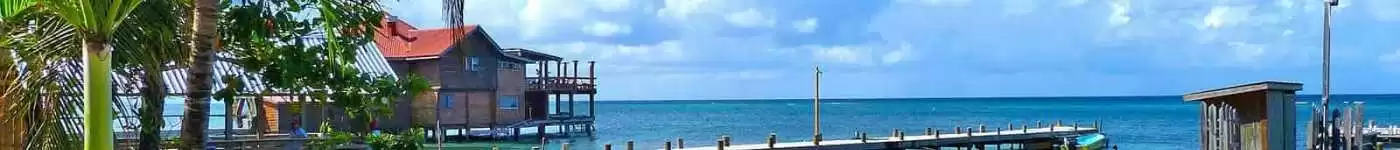
Your search criteria:
Honduras
Routes naturally divide between islands and shore. Among the Bay Islands, reef crests run close to land, so views shift from emerald jungle to aquamarine shelves; drop-offs and patch reefs mark the edge of the Mesoamerican system. West Bay’s arc on Roatán sits opposite shallow banks and lagoons, while Utila’s low profile and cays feel low-slung; Guanaja’s higher ridges add a mountainous backdrop. Back on the mainland, the estuary belt between La Ceiba and Tela reads quieter. Cuero y Salado’s canals braid through mangroves toward the sea, opening to mirror-like lagoons at slack tide. Around Tela Bay, the Jeannette Kawas (Punta Sal) peninsula forms a forested headland with beaches and nearshore coral. Continue east beyond Trujillo and the coast grows wilder toward the Mosquitia: long beaches, river mouths, and coastal lagoons lined by palms. The storyline culminates in the Río Plátano Biosphere Reserve, a vast watershed running from interior mountains to the Caribbean. Here, lowland rivers, oxbow lakes, and forested ridges meet a truly remote coast where sea and jungle share the horizon. Across all of it, color and geometry drive the experience—green mangrove, pale sandbars, and the reef’s blue band—arranged in short, scenic segments suited to unhurried coastal cruising.